About World atlas & world map MxGeo
• Dark Mode Support • Search for countries, cities, rivers, mountains, lakes or coordinates • World Explorer: largest cities, longest rivers and highest mountains World atlas, world map and educational app for geography. F
• Dark Mode Support
• Search for countries, cities, rivers, mountains, lakes or coordinates
• World Explorer: largest cities, longest rivers and highest mountains
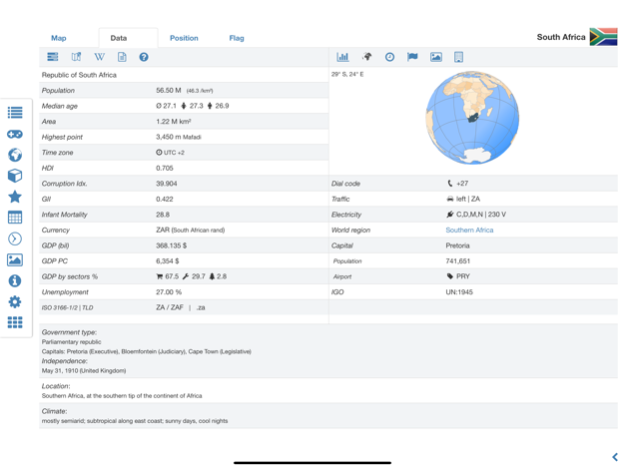
World atlas, world map and educational app for geography. Flags, position maps and basic data and basic maps with regional units for more than 260 countries and territories of the world. Detailed political maps and comprehensive economical and statistical country data for all African countries.
• Search for countries, major cities, rivers, deserts, lakes, mountains or coordinates
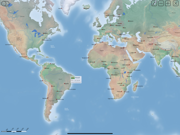
• Interactive political world and continent maps
• Flags, basic maps and basic data for over 260 countries and territories
• Shaded relief layer for world and continent maps
• Geography quiz: capitals, flags, federal states, ...
• Country comparison, favorite list and distance calculator
• World-explorer: the smallest, largest, ... countries, the largest cities, longest rivers and highest mountains
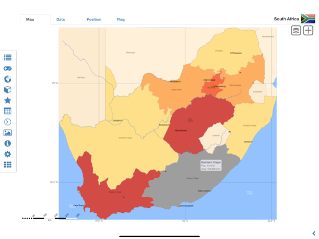
• Choropleth maps: area, population and HDI
• Political maps and comprehensive data of all african countries
• World clock and time zone map
• No advertising
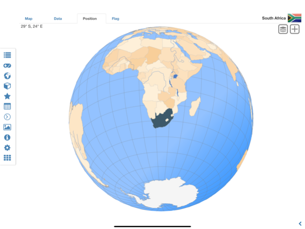
Explore the world by political world and continent maps. Learn where each country in the world is located. View its position highlighted on a digital globe. Overview of the largest cities, longest rivers and highest mountains. Create your favorite color theme or choose from different color schemes for map display.
Do you know the flag of Zambia? Yes? Perfect. Do you also know in which country Mount Kilimanjaro is located? Increase your general geography knowledge in a playful manner. MxGeo Quiz: test your geographic literacy on various topics:
• Do you know the longest rivers?
• Federal states / provinces for selected countries
• Test your knowledge about the capitals of Africa
• Recognize the proper country flag based on the outline map
• Do you know the top-level domains of the world's countries?
• Guess the highlighted country on the virtual globe
• Guess the correct country based on the flag
• Do you know the ISO countries codes of the world?
• Do you know the mountains of Africa?
Geo learning app and educational game which is fun for everyone whether children, adults, seniors or teachers. Get ready for your next stay abroad while enjoying this great world almanac including time zones and statistical data, such as population growth and other key figures. Or prepare for your next geography lesson with this genius digital world map. If not traveling our world atlas lets you explore the world just only virtually.
Free version includes flags, position maps and basic data and basic maps for more than 260 countries and territories as well as comprehensive data and political maps for all African countries. Get “World atlas & world map MxGeo Pro” with data and maps for more than 260 countries and territories of the world: Europe, Asia, North America, Africa, Oceania and South America.
Jan 14, 2024
Version 9.1.2
• Updates for maps and data
• Bug fixes and improvements
• Enhanced chart visualization
8.x:
• New choropleth map: population density
• Country comparison and World Explorer new key indicator: population density
6.x:
• Search for countries, major cities, rivers, mountains, lakes and coordinates
• World Explorer: largest cities, longest rivers and highest mountains
• Distance calculator: cities, states, mountain, lakes, ...
5.x:
• Country info: government type, climate and date of independence
• Distance calculator: more cities
• Dynamic scale bars
Previous Versions
Here you can find the changelog of World atlas & world map MxGeo since it was posted on our website on 2016-11-05 07:32:14.
The latest version is 9.1.2 and it was updated on 2024-04-19 17:15:09. See below the changes in each version.
World atlas & world map MxGeo version 9.1.2
Updated At: 2024-01-14
Changes: Jan 14, 2024
Version 9.1.2
• Updates for maps and data
• Bug fixes and improvements
• Enhanced chart visualization
8.x:
• New choropleth map: population density
• Country comparison and World Explorer new key indicator: population density
6.x:
• Search for countries, major cities, rivers, mountains, lakes and coordinates
• World Explorer: largest cities, longest rivers and highest mountains
• Distance calculator: cities, states, mountain, lakes, ...
5.x:
• Country info: government type, climate and date of independence
• Distance calculator: more cities
• Dynamic scale bars
World atlas & world map MxGeo version 8.9.6
Updated At: 2023-07-14
Changes: Jul 14, 2023
Version 8.9.6
• Updates for maps and data
• Bug fixes and improvements
8.x:
• New choropleth map: population density
• Country comparison and World Explorer new key indicator: population density
6.x:
• Search for countries, major cities, rivers, mountains, lakes and coordinates
• World Explorer: largest cities, longest rivers and highest mountains
• Distance calculator: cities, states, mountain, lakes, ...
5.x:
• Country info: government type, climate and date of independence
• Distance calculator: more cities
• Dynamic scale bars
World atlas & world map MxGeo version 8.7.1
Updated At: 2022-10-18
Changes: Oct 18, 2022
Version 8.7.1
• Updates for maps and data
• Updates for Human Development Index (HDI) data
• New choropleth map: population density
• Country comparison and World Explorer new key indicator: population density
6.x:
• Search for countries, major cities, rivers, mountains, lakes and coordinates
• World Explorer: largest cities, longest rivers and highest mountains
• Distance calculator: cities, states, mountain, lakes, ...
5.x:
• Country info: government type, climate and date of independence
• Distance calculator: more cities
• Dynamic scale bars
World atlas & world map MxGeo version 8.5.0
Updated At: 2022-03-12
Changes: Mar 12, 2022 Version 8.5.0
• Updates and corrections for maps and data
• Bug fixes and improvements
• Search for principal subdivisions like states or provinces
6.8.x:
• Search for countries, major cities, rivers, mountains, lakes and coordinates
• World Explorer: largest cities, longest rivers and highest mountains
6.2.x:
• Country info: government type, climate and date of independence
• Distance calculator: more cities
• Dynamic scale bars
World atlas & world map MxGeo version 8.3.1
Updated At: 2021-10-28
Changes: Oct 28, 2021 Version 8.3.1
• Corrections and updates for maps and data
• Bug fixes and improvements
• Search for principal subdivisions like states or provinces
6.8.x:
• Search for countries, major cities, rivers, mountains, lakes and coordinates
• World Explorer: largest cities, longest rivers and highest mountains
• Quiz: Do you know the longest rivers on Earth?
6.2.x:
• Country info: government type, climate and date of independence
• Distance calculator: more cities
• Dynamic scale bars
World atlas & world map MxGeo version 8.2.8
Updated At: 2021-08-14
Changes: Aug 14, 2021 Version 8.2.8
• Search for principal subdivisions like states or provinces
• Corrections and updates for maps and data
• Bug fixes and improvements
6.8.x:
• Search for countries, major cities, rivers, mountains, lakes and coordinates
• World Explorer: largest cities, longest rivers and highest mountains
• New Quiz: Do you know the longest rivers on Earth?
6.2.x:
• Country info: government type, climate and date of independence
• Distance calculator: more cities
• Dynamic scale bars
World atlas & world map MxGeo version 8.2.0
Updated At: 2021-07-07
Changes: Jul 7, 2021 Version 8.2.0
• Search for principal subdivisions like states or provinces
• Corrections and updates for maps and data
• Bug fixes and improvements
6.8.x:
• Search for countries, major cities, rivers, mountains, lakes and coordinates
• World Explorer: largest cities, longest rivers and highest mountains
• New Quiz: Do you know the longest rivers on Earth?
6.2.x:
• Country info: government type, climate and date of independence
• Distance calculator: more cities
• Dynamic scale bars
World atlas & world map MxGeo version 6.8.15
Updated At: 2021-01-21
Changes: Jan 21, 2021 Version 6.8.15
• New Quiz: Do you know the longest rivers?
• Updates for maps and data: HDI 2020, ...
• Search for countries, major cities, rivers, deserts, lakes, mountains or coordinates
• World Explorer: largest cities, longest rivers and highest mountains
6.2.x:
• New Quiz: Federal states for selected countries
• Country data now with info about government type, climate and date of independence
• Distance calculator: more cities
5.x:
• Administrative area maps for selected countries
• Top cities by population for each country and continent
• Temperature data: Centigrade or Fahrenheit
World atlas & world map MxGeo version 6.8.11
Updated At: 2020-10-25
Changes: Oct 25, 2020 Version 6.8.11
• Search for countries, major cities, rivers, mountains, lakes or coordinates
• World Explorer new data: largest cities, longest rivers and highest mountains
• Corrections and updates for maps and data
• Bug fixes and improvements
6.2.x:
• Dynamic scale bar
• Country data now including info about government type, climate and date of independence
• Distance calculator: more cities
• Virtual World Tour
5.x:
• Temperature data: Centigrade or Fahrenheit
• New key figure HDI in World Explorer
World atlas & world map MxGeo version 6.8.0
Updated At: 2020-07-08
Changes: Jul 8, 2020 Version 6.8.0
• New Search for countries, major cities, rivers & mountains or coordinates
• HDI data Update
• Corrections and updates for maps and data
• Bug fixes and improvements